Here is the 2nd article in the series dedicated to mountain navigation.
After discovering the map, we will see what the compass and altimeter are used for.
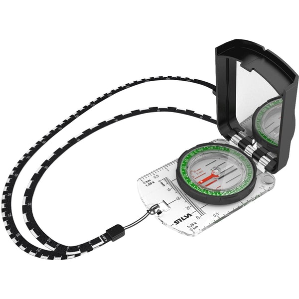
THE COMPASS:
The compass is made up of 3 parts:
- A magnetic needle that turns and whose red part indicates magnetic north.
- A rotating dial graduated from 0° to 360°.
- A graduated plate with a sighting mark.
What is a compass used for?
There are several possible uses:
- determining your position
- taking a bearing on a map to follow a direction
- following a given direction on the ground
How to find north with a compass?
The magnetic north is indicated by the red side of the needle. Warning: it is slightly different from geographic north (top of maps): this is the magnetic declination.
This difference fluctuates over time. In our latitudes, except for long journeys, it can be neglected.
Be careful, the compass, whatever the model, is sensitive to metal objects and electronic devices. You will need to keep them as far away as possible from your compass.
THE ALTIMETER:
In the mountains, altitude is a primary factor in estimating a position. The altimeter gives the altitude based on atmospheric pressure.
It must be regularly calibrated by passing known elevation points. A good altimeter must be “temperature compensated” otherwise it will be unusable for precise navigation.
How does it work?
Atmospheric pressure is linked to the weight of the air column. The higher the altitude, the lower the height of the air column, and therefore the lower the pressure.
Theoretically and under normal conditions, one measures 1013 mBars at sea level, 899 mBars at 1000 m, 795 mBars at 2000 m, 701 mBars at 3000 m, 616 mBars at 4000 m, 540 at 5000 m…
To evaluate altitude, the altimeter is based on a pressure variation and calculates the corresponding altitude variation.
Reference conditions (called “normal”) are 15°C and 1013 mBar at sea level. If these conditions are not met, altitude estimates are distorted. Indeed, atmospheric pressure is linked to the weather. The normal pressure at sea level is 1013 mBars, but it may vary from 980 mBars (low pressure) to 1040 mBars (high pressure), always at the same level.
In short, this means that for a given place, the pressure varies according to the weather and therefore an altimeter reading will also vary. That is why it is essential to recalibrate your altimeter when passing at known points, especially in changing weather.
Is the altitude indicated by an altimeter reliable?
There are two types of errors when using an altimeter:
- a first, purely technical, due to a possible variation in the sensor’s temperature. This temperature variation causes a variation in the measured pressure, and therefore a variation in the displayed altitude. To correct this error, some altimeters are equipped with a thermometer and are called “temperature compensated“.
- a second error, due to a temperature difference of the atmosphere compared to the reference conditions (15°C). The pressure gradient is defined for a reference temperature at sea level. A temperature deviation T from this reference causes a relative error in estimated altitude on the order of 3.5 meters per 1000 meters and per °C. Actually, the error is T/288 (percentage).
Numerical example of the second type of error: A temperature of 0°C at sea level, that is a deviation T of 15°C from the reference temperature. The variation in altitude indicated by the altimeter under these conditions will be overestimated by 15/288, or 5.2%. Since the last calibration, if the altimeter indicates that you have descended 1000 meters, in fact, you have only lost 948 meters…
Hence the usefulness of calibrating the altimeter as often as possible. This error is not compensated by altimeters.
The altimeter is a valuable navigation tool, but it is sensitive and the altitude given is only an estimate. The error remains very low in most cases. It is essential to choose one temperature compensated and to calibrate it in altitude whenever possible (passing a known point).
With these three instruments (map, compass, and altimeter), some orientation techniques and above all training, you will be ready to navigate, even in poor conditions (weather and visibility).
Additionally, the use of a GPS (Global Positioning System) can be useful. This small device will make orientation easier but it absolutely does not replace knowledge of the basic techniques. Electronics can always fail when you need it most. Also, depending on the area where you are moving in the mountains, there may be shadow zones preventing you from correctly receiving satellites. And without a minimum number of satellites (5 generally for three dimensions), the GPS will be of no use to you.
In the next article of the series, we will discover some basic orientation techniques.