In the mountains, for a responsible and autonomous practice, it is essential to know the different orientation techniques.
Technological evolution, with the arrival of GPS mainly, can provide significant assistance, but it should remain a complement.
The basic techniques must be mastered nonetheless, as electronics do not yet offer an infallible level of reliability. Many limitations can occur in the use of GPS (shadow zones, dead batteries…).
On the other hand, GPS navigation allows for a gain in speed during progression (abandoning the search for remarkable points) and offers great ease for orientation without visibility.
Over the next few weeks, we will propose a series of articles on mountain orientation, from the presentation of equipment to advanced navigation techniques without visibility, not forgetting of course the basic orientation techniques. This week, we are starting with a brief presentation of the equipment and more explanations on hiking maps.
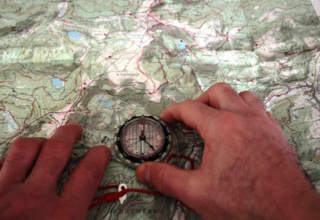
Traditional orientation involves the map, the compass, and the altimeter.
- The map: it is the basic tool of any orientation. In many cases and with good visibility, a good map (and especially good reading skills) is enough to orient oneself correctly. It is also used to prepare the walking plan before the hike.
- The compass: it allows measuring the azimuth of different parts of the route on the map and following it on the ground.
- The altimeter: it indicates altitude according to atmospheric pressure. Pressure variations linked to weather changes mean it must be regularly calibrated by passing through known elevation points. It is an indispensable complement to the compass and the map. Indeed, in the mountains, altitude is a crucial element in estimating a position.
THE MAP
A map is the representation in two dimensions of a landscape, of a relief. This representation follows rules, symbols, artifices.
It is important to be properly familiar with map reading to interpret it quickly. With practice, you will be able to immediately relate the relief to its representation on the map, and vice versa. But for that, you have to “devour” maps. At the slightest opportunity, you will have to bring it out, read it, visualize on the terrain the representation of the landscape on the map.
Before doing all this, you must orient this map:
to match the landscape and its representation, the map and the landscape must be oriented the same way… The North of the map must correspond to the North of the terrain.
For this, two solutions:
- align recognizable points (peaks, passes) with their representation on the map, like an orientation table.
- orient the map using the compass. The North of the map and the North of the compass must be in the same direction.
But beware! The map indicates the geographic North (for us Europeans, North is at the top of the map) and the compass indicates magnetic North. These two Norths are different, and this difference is called the magnetic declination. It varies according to geographic position and also over time.
This declination is indicated in the legend of the map, as well as its annual variation.
Currently, at our latitudes, it is negligible, except in the case of long navigation.
Reading a map
- The scale: it would of course be impossible and unnecessary to reproduce a landscape on a map in the same dimensions. Landscapes are therefore represented “smaller” than in reality. The ratio between the distance represented on the map to the real distance is called the scale. Hikers and mountaineers use maps at 1/25000, which means that 1 cm on the map represents 250 m on the ground.
- Planimetry: it is the set of symbols and representations of the landscape, without considering relief (roads, paths, houses, monuments, watercourses). All these symbols are explained in the legend.
- Reliefs: in the mountains, the relief is an important element of the landscape. Contour lines represent this. A contour line represents an altitude on the map.
On a 1/25000 map, contour lines are spaced 10 m apart. This distance between lines is called the contour interval and is indicated in the legend.
Every 50 m, a line, called “master”, is drawn with a thicker stroke. When space permits, the altitude of this master line is indicated. Reading is done in the “natural” direction (meaning that the upstream of the relief is towards the top of the numbers).
To facilitate relief interpretation, most current maps (especially the most common ones, the IGN TOP 25) use shading. Ridges cast a fictitious shadow on the drawing, corresponding to a sun located 35° above the horizon, in the Northwest.
Relief interpretation
- The slope: the altitude interval represented by the space between two successive contour lines is constant; their spacing on the map materializes the steepness of the slope. Closely spaced contour lines indicate a steep slope. Conversely, widely spaced lines indicate a gentle slope. On a 1/25000 map, on slopes greater than 45°, it is very difficult to distinguish the lines from each other.
- The shapes: interpreting volumes is a bit more delicate. At first, it is easy to confuse a ridge with a talweg (a kind of “big ditch”). Shading helps you, provided you read the map in the correct direction (natural reading position of the names on the map). If you turn the map over, the shading-related relief impressions are reversed, and you will confuse these ridges and talwegs.
In the next article we will discover the compass and the altimeter, two other essential tools for mountain orientation.