You sink into the cool undergrowth of an unknown Alpine massif, unaware of the reward awaiting you higher up. Right from the parking lot exit (usual departure towards Bovère, Taninges), the trail gently climbs beneath age-old conifers. The air is filled with the scent of resin and damp earth.
As you ascend, you first cross a dense forest where the song of the finch mingles with the rustling of the wind in the needles. Then the vegetation clears: first some flowering bushes, then suspended alpine meadows, and finally a mineral landscape sculpted by millennia of erosion. In places, the route opens onto viewpoints immersed in a sea of fir trees. The sounds of the valley gradually fade away, replaced by a silence made up of light wind and distant echoes of birds of prey. This striking contrast, the cool shade of the forest followed by the dazzling brightness of the heights, greets you at every step.
The route can be broken down into easy-to-follow stages:
- From the parking lot to the wooded saddle. Start on a drivable track then a marked trail (yellow arrows) heading north. You cross a stream, tackle a few hairpin bends in the undergrowth, then reach a first saddle where the forest thins out.
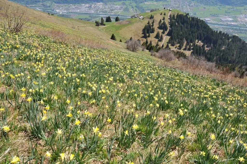
- From the undergrowth to the alpine meadows. A slight descent followed by a new ascent leads you onto a sparse high-altitude plateau. Here, in spring, daffodils and gentians speckle the meadows. In May, wild daffodils abound along the path. With a little luck, you might spot a marmot whistling at a distance, or a furtive roe deer.
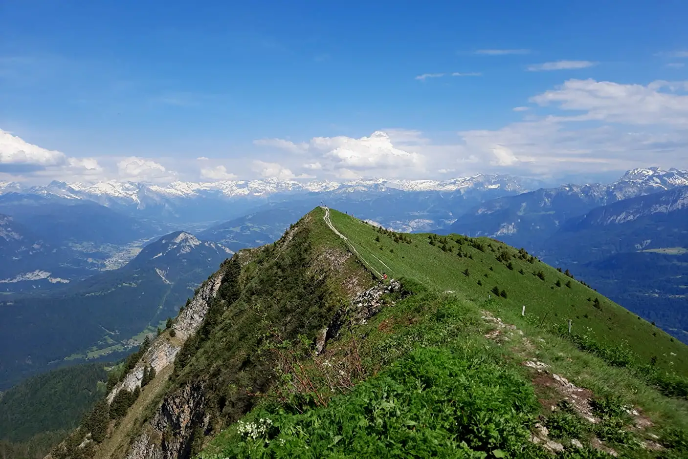
- The last rocky hairpins. Above 1,500 m, vegetation becomes sparse. The path climbs along a ridge through steep grassy slopes, sometimes eroded. At the height of the Rionffer pass (≈1587 m), you can already see a iron cross on the right marking the summit. Count about 700 meters of elevation gain from Bovère and nearly 4 hours for the round trip. The ascent remains accessible in good physical shape all year round (on foot or ski touring), but it can be muddy in spring and cold in winter. Yellow markers line the summer route; in winter, be cautious of cornices and plan snow equipment.
Atmosphere and Alpine Nature
The atmospheres vary with the effort and seasons. Early in the morning or evening, slopes planted with rhododendrons are bathed in golden light. The start of the hike in the forest is cool and misty on some days, while in summer the warmth of the sun’s rays filters through the branches. On the ridge, a north wind cools the air, and you hear the distant flight of a bird of prey.
Each season offers its show:
- in spring, the meadows bloom (gentians, anemones, primroses, daffodils, crocuses) and wildlife is very active (marmots, butterflies, and distant rutting stags);
- in summer, rhododendron hearts explode with colors and the view is clear under a blue sky;
- in autumn, the undergrowth takes on burning shades of gold and red, creating a striking contrast with the still green ridges;
- in winter, the summit is covered with snow and the silence is impressive, only broken by the gentle splash of a sometimes frozen stream.
Don’t forget to bring good mountain shoes, water, and warm, waterproof clothes – the weather at altitude changes quickly. An IGN map (top 25 3429ET) and a GPS can be useful on some poorly signed sections. In short: travel light and well prepared to fully enjoy the pristine nature.
A Breathtaking Panorama
Once near the summit cross, the reward is complete. The panorama opens 360°, embracing so many reliefs that it’s impossible to list them all. From here, the most famous is of course the Mont Blanc (4,809 m) which dominates the horizon with its immaculate mass. Opposite, the Aiguilles de Chamonix and the sharp silhouette of the Dent du Géant tower over the surrounding glaciers.
On each side, the Swiss peaks reveal themselves clearly: you recognize the Dents du Midi range and the Aiguille Verte overlooking Valais. Below stretches the azure shine of Lake Geneva surrounded by vineyards, and, in good weather, the Jura Mountains can be seen in the background, bluish in the distance. Even the Salève (near Geneva) appears on the horizon.
This vast panorama literally encompasses “Jura, Léman, Mont Blanc massif, Bargy range, and Salève”. You have the feeling of being on a natural balcony in the heart of the Alpine Europe. The peaks seem within reach: it’s like touching the sky of the Alps.
Every glance sweeps a different picture: to the west, the Arve valley winds between villages (Marignier, Bonneville, Cluses) while the Bargy and the Aravis sketch jagged ridges. To the north, the Giffre valley and its deep forests extend to the villages of Saint-Jeoire and Viuz-en-Sallaz. Turning your eyes around the rock, you can almost embrace all the surrounding municipalities (Ayse, La Tour, Saint-Jean-de-Tholome…) which are dominated by this mountain. This magnificent panorama fully justifies the ascent: every summit glimpsed, every lake seen, tells the story of these Haute-Savoie landscapes.
A Summit Known Only to Locals

After this unforgettable walk, the name of this exceptional vantage point, known only to locals, can finally be revealed. It is the Môle, a pyramidal silhouette culminating at 1,863 m. A small mountain of the Chablais, the Môle stands like a sentinel at the crossroads of the Arve and Giffre valleys, overlooking Bonneville and its surrounding villages. Its modest altitude concealed its grand panorama well: indeed, few summits offer such a “Jura, Léman, Mont Blanc massif…” spectacle.
This little-known elevation, far from the crowds of large massifs, remains a secret jewel of the French Alps. On your return, you will leave with your head full of white and blue images, sore thighs, and the heart eager to come back and climb this unique viewpoint.
Practical Tips and Useful Information
- Access: The main parking lot is at the end of the Bovère road (in the hamlet of Bovère, Commune of Saint-Jean-de-Tholome). The route is also accessible from the village of Mieussy or Marignier, but these paths are much longer and steeper. For example, the loop from Marignier is about 13 km and 1,500 m elevation gain (about 8 hours walking, very difficult).
- Marking and trails: The main trail (yellow triangles) is marked and frequented. It first crosses pastures, then follows an old mule track and a clearly visible grassy ridge. Near the summit, a metal cross and a cairn mark the highest point. The return is along the same route (loop possible by joining the Granges trail). The IGN map 3429ET (Bonneville – Cluses – Faucigny) and a GPS are recommended for those unfamiliar with the area.
- Duration and elevation gain: Count about 4 hours for the ascent and descent under normal conditions (720 m elevation gain from Bovère). Some sources indicate 4–5 hours in summer. Carrying water and snacks is essential, especially as there is no water point after the parking lot.
- Recommended equipment: good high hiking boots, warm and rainproof clothes, cap/sunglasses, food and water (at least 1 L). In winter: crampons and a rope as the final ridge can be slippery. A first aid kit and charged mobile phone are advised.
- Best period: The ascent is ideally done from May to October. In May–June, the alpine pastures bloom (numerous daffodils and crocuses often carpet the edges of the path and the summit slopes of the Mole) and marmots emerge. Summer offers maximum visibility over the glaciers. Autumn (September) is renowned for its flaming colors and stable weather. In winter, it is possible to do this outing on snowshoes or touring skis (to be avoided in strong winds or avalanche risk).
The Final Word
The region also features nearby curiosities: the peaceful Lac du Môle (a small lowland lake at La Tour that hosts rich wildlife), traditional hamlets like Ossat or Tréchauffé (portraits of old barns), and the famous Cirque du Fer à Cheval at the bottom of the Giffre valley. Between stages, don’t hesitate to taste a local tomme or farmhouse reblochon, a welcome comfort at altitude.