Here is the 4th article of our series dedicated to mountain orientation.
After discovering the map, the compass, and the altimeter, and especially how to use them with basic techniques to orient yourself with good visibility, we will now discover some “advanced” techniques (deliberate error, tangent to the curve) to use with reduced visibility, but very delicate to implement.
So far we have considered that visibility was good. But this is not always the case in the mountains and it is often in these conditions that you will need to orient yourself the most. And this is not the easiest!
Determining your position on the terrain by the tangent to the curve method
This is about finding your position on the map.
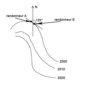
It is assumed that you know the approximate area in which you may be. Since you have a properly calibrated altimeter, you know on which contour line you are.
You then simply have to take, on the terrain, the azimuth of the perpendicular to the line of greatest slope, place your compass on the map on the terrain’s azimuth, and slide it along the contour line until it just touches it: This is the sought position.
Complicated? Indeed, but actually, a small variation consists of sending your teammate a little ahead of you but staying precisely at the same altitude (figure 1).
You just need to take the azimuth of your teammate / moving landmark. Since you are both on the same contour line, you will have the azimuth of the tangent to the curve!!!
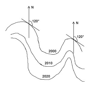
Depending on the nature of the terrain (figure 2), it may be necessary to repeat this operation several times in different places.
Note: this technique may be more or less easy to perform depending on the terrain. It will only be effective if you practice it regularly.
Following an azimuth without visibility
For this, it is imperative to reduce the distance between you and the point you are aiming at. In any case, you have no choice, I remind you that visibility is very limited!
You therefore set several intermediate progression points and choose an unavoidable point as your final objective. For example, a rock formation or a contour line (well set altimeter strongly recommended).
An interesting characteristic point to aim at is one of your teammates. You make them progress ahead of you at the limit of visibility, guiding them by voice according to your compass reading.
It is quite an effective technique, which will certainly slow you down a bit, but much less than the classic progression technique without visibility. But it is preferable to be well trained beforehand under penalty of guaranteed error.
With the classic technique, it’s more or less the same except that when you make your teammate move forward, you remain still.
Once they are at the limit of visibility, you make them stop, eventually correct their heading, and then catch up with them. And so on… Easier but extremely long.
The disadvantage of these techniques is that, even with practice, you will have an error, certainly minor if you are well trained, but sufficient to miss the refuge you are aiming for.
To counter this, the deliberate error technique is used.
It is known that there will be a small error during navigation but you do not know in which direction it will occur: a few degrees to the right or to the left???
When choosing the azimuth (a characteristic stopping point), a deliberate error is introduced in a direction that is known.
You then simply follow this “false” azimuth and, once the stopping point is reached, correct in the opposite direction of the introduced error. Obviously, do not take an error of 2 km!!!
For example: you want to reach the refuge at 2120m, due north. You choose an azimuth a little to the left (for example) of the real azimuth until the desired altitude.
You then just have to follow the contour line (here to the right) until the objective. If you had aimed directly at the refuge (north), there would have been a good chance that once the altitude is reached, you would not be on the refuge and wouldn’t know which direction to take.
These are quite delicate techniques to implement but once well mastered, they can be very useful. It is even the only way to navigate relatively reliably without visibility, apart from GPS (when it works).
So, during your hikes, dedicate some time to practicing them and you will see that it is, ultimately, not so complicated.